


Handlekurven din

Kommentar

Alle bestillinger vil bli brukt USD. Innholdet i din nåværende handlekurv vises CYN, Du vil bruke USD Beregnet med siste valutakurs.

utsolgt

Noen produkter er ikke lenger tilgjengelige. Handlekurven din er oppdatert.

Har du en rabattkode?
Brukte rabattkoder lagres på kontoen din
Delsum
Rabatt

Denne rabattkoden kan ikke brukes i forbindelse med andre kampanjer eller rabatttilbud.

total
Beregn avgifter og fraktkostnader ved betaling.
Gratis levering på alle bestillinger.
NOK

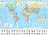
Collins World Wall Laminated Map 5952436

Sale price NOK kr100.50 Regular price NOK kr201.00

Ordresammendrag

Collins World Wall Laminated Map
100.50
Har du en rabattkode?
Brukte rabattkoder lagres på kontoen din

Delsum
Fraktkostnader beregnes ved kassen.

eller

Kjøpsmetode
Detaljer

Explore the world with a Collins wall map

Fully updated world map to include the latest political changes. The map contains politically coloured mapping which shows each country and their capital city, major roads, and cities and towns clearly. Also included are national flags, key statistics for every country and inset maps of the polar regions.

The map is printed on high quality paper and comes rolled in a fully recyclable cardboard box – ideal as a poster for any classroom, bedroom or office wall.

Area of coverage:

All of the world, centred on the Greenwich Meridian, and including maps of the North and South Pole regions.

Scale:

1:30 000 000; 1 cm to 300 km; 1 inch to 480 miles

Size:

700 x 915 mm (27.5 x 36 inches)

Other versions available:

Paper flat map (ISBN 978-0-00-849255-7)

    Se alle detaljene
    Autentisering
    Hvis du ikke har en konto, klikker du på Opprett konto.bli medlem